Conservation area data
Last updated: 10 April 2026
Presumption to publish
Ordnance Survey has confirmed that our assessment of this dataset is correct, provided the data meets our specification.
Read more about presumption to publish.
View the discussion on Github.
There are 2 datasets you must provide for conservation area data:
Format
You can provide data in one of these formats:
- CSV
- GeoJSON
- GML
- Geopackage
These may be uploaded to a single URL, or served via an OGC WFS or ArcGIS API.
Field names
You can provide field names using hyphens, underscores or spaces.
For example:
start-datestart_datestart date
These are all valid, and any uppercase characters will be converted to lowercase.
Conservation area dataset
This dataset is about conservation areas. These are areas of special architectural or historic interest with a character or appearance that must be preserved or enhanced. Don’t worry if you don’t have all the data we’ve asked for available right now. If you give us what you’ve got, we can help you fill in the gaps later.
A complete record should contain the following fields (columns):
reference
A reference or ID for each conservation area that is:
- unique within your dataset
- permanent - it doesn't change when the dataset is updated
If you don't use a reference already, you will need to create one. This can be a short set of letters or numbers.
Example: CA01
name
The official name of the conservation area.
Example: Old Market
organisation
The code for the organisation responsible for the conservation area. If the responsible organisation is your local authority, leave this field blank and we will default to that. If another organisation is responsible, for example Historic England, then enter the code for that organisation.
Example: local-authority:BUC
Create this code by using the relevant prefix, a colon (:), and the reference for your organisation from this list of organisations.
geometry
The boundary for the conservation area geography as a single polygon or multipolygon value. All points in the polygon should be in the WGS84 coordinate reference system if possible. If you can’t do this, give us what you have and then we can transform it into WGS84. However, this could mean there’s a small loss of precision when we do the transformation. If you’re providing geometry in a CSV, geometry should be in well-known text (WKT).
Example: MULTIPOLYGON (((1.188829 51.23478,1.188376 51.234909,1.188381 51.234917,1.187912 51.235022...
If you’re providing geometry in a GeoJSON, GML or Geopackage, use the associated geometry format.
designation-date
The date that the conservation area was officially designated, written in YYYY-MM-DD format.
Example:
1984-03-28
With dates, some data is better than no data, so:
1984is fine1984-03is better1984-04-28is brilliant
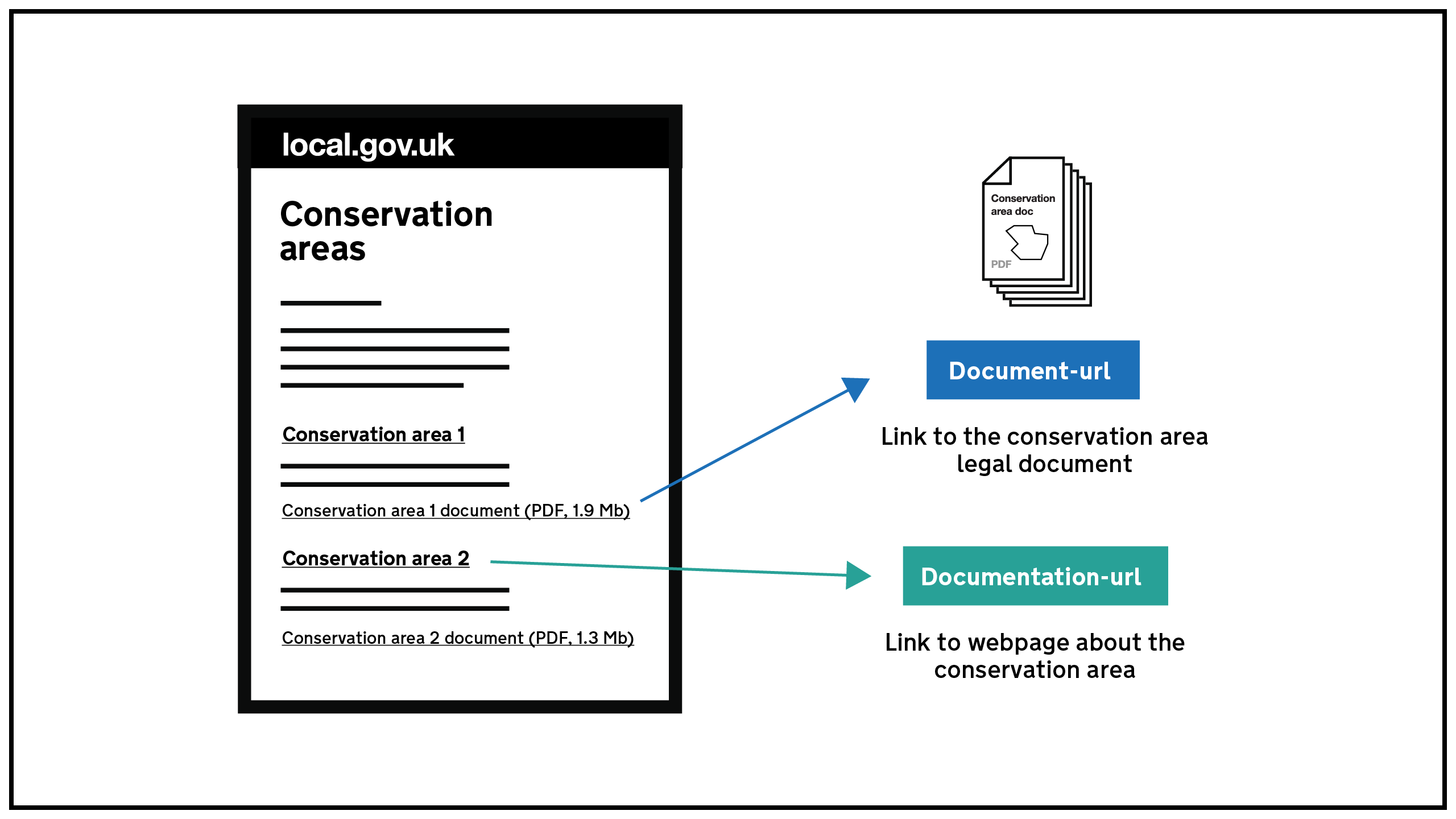
document-url
A URL to the document containing the authoritative source for the area. This is usually a PDF containing the area drawn on a map.
Example: http://www.LPAwebsite.org.uk/data/conservationareas/smithroad-area.pdf
documentation-url
The URL of the webpage on your website that introduces the document.
Each document should be linked to from a documentation webpage that includes a short description of the data and the document you’re linking to. Each conservation area should have a unique URL. This means you can create a separate page for each one, or you could list several on one page. If you do that, there must be a separate anchor (fragment identifier) for each one. This means each section of your page should have its own URL. Most publishing systems will allow you to use a hashtag to create the identifiers for each conservation area you list - as in the examples shown.
Examples:
One conservation area per page:
http://www.LPAwebsite.org.uk/conservationareas/smithroad
More than one conservation area per page with an anchor link for each one:
http://www.LPAwebsite.org.uk/conservationareas#smithroad
http://www.LPAwebsite.org.uk/conservationareas#broadhousepark
notes
Optional text on how this data was made or produced, or how it can be interpreted.
entry-date
The date the record was last updated.
If the entity has never been updated, enter the same date as start-date.
Write in YYYY-MM-DD format.
Example:
2022-12-20
With dates, some data is better than no data, so:
2022is fine2022-12is better2022-12-20is brilliant
start-date
The date the validity of the record starts, written in YYYY-MM-DD format. Usually, this will be the same as the designation date. If anything about the conservation area has changed, for example, the boundary, it should be the date of that change.
Example:
1984-04-25
With dates, some data is better than no data, so:
1984is fine1984-04is better1984-04-25is brilliant
end-date
Where the conservation area is no longer valid, this should be the date that it was no longer in effect, written in YYYY-MM-DD format. If this does not apply, leave the cell blank.
Example:
1999-01-20
With dates, some data is better than no data, so:
1999is fine1999-01is better1984-01-20is brilliant
Conservation area documents dataset
This dataset is about documents that provide sources for the information contained in the conservation areas dataset. If you can, you should provide this dataset in addition to the conservation area dataset.
These documents are the authoritative source and provide the context around the history and impact of the conservation area. They can be:
- draft directions
- area appraisals
- notices of conservation area designations
- management plans
- gazette entries
Don’t worry if you don’t have all the data we’ve asked for available right now. If you give us what you’ve got, we can help you fill in the gaps later.
A complete record should contain the following fields (columns):
reference
A reference or ID for each document that is:
- unique within your dataset
- permanent - it doesn't change when the dataset is updated
If you don't use a reference already, you will need to create one. This can be a short set of letters or numbers.
Example: CADOC01
name
The title of the document.
Example: Notice of Old Market conservation area designation
conservation-area
The reference for the conservation area this document refers to, as used in the conservation area dataset.
Example: CA1
documentation-url
The URL of the webpage introducing the document.
Each document should be linked to on a documentation webpage that includes a short description of the data. The website URL should be unique for each conservation area, either by creating a separate page or a separate anchor (fragment identifier) for each one.
Example: http://www.LPAwebsite.org.uk/data#conservationarea1
document-url
The URL of the document.
Example: http://www.LPAwebsite.org.uk/conservationarea1.pdf
document-type
The code for the type of document this record refers to. Find the code you need using this finder tool.
notes
Optional text on how this data was made or produced, or how it can be interpreted.
entry-date
The date the entity was last updated.
If the entity has never been updated, enter the same date as start-date.
Write in YYYY-MM-DD format.
Example:
1984-03-28
With dates, some data is better than no data, so:
1984is fine1984-03is better1984-03-28is brilliant
start-date
The date the document was published, written in YYYY-MM-DD format.
Example:
1984-03-28
With dates, some data is better than no data, so:
1984is fine1984-03is better1984-03-28is brilliant
end-date
The date the document was withdrawn or superseded by another document, written in YYYY-MM-DD format. Leave this blank if the document is still relevant to planning.
Example:
1984-03-28
With dates, some data is better than no data, so:
1984is fine1984-03is better1984-03-28is brilliant