Conservation area
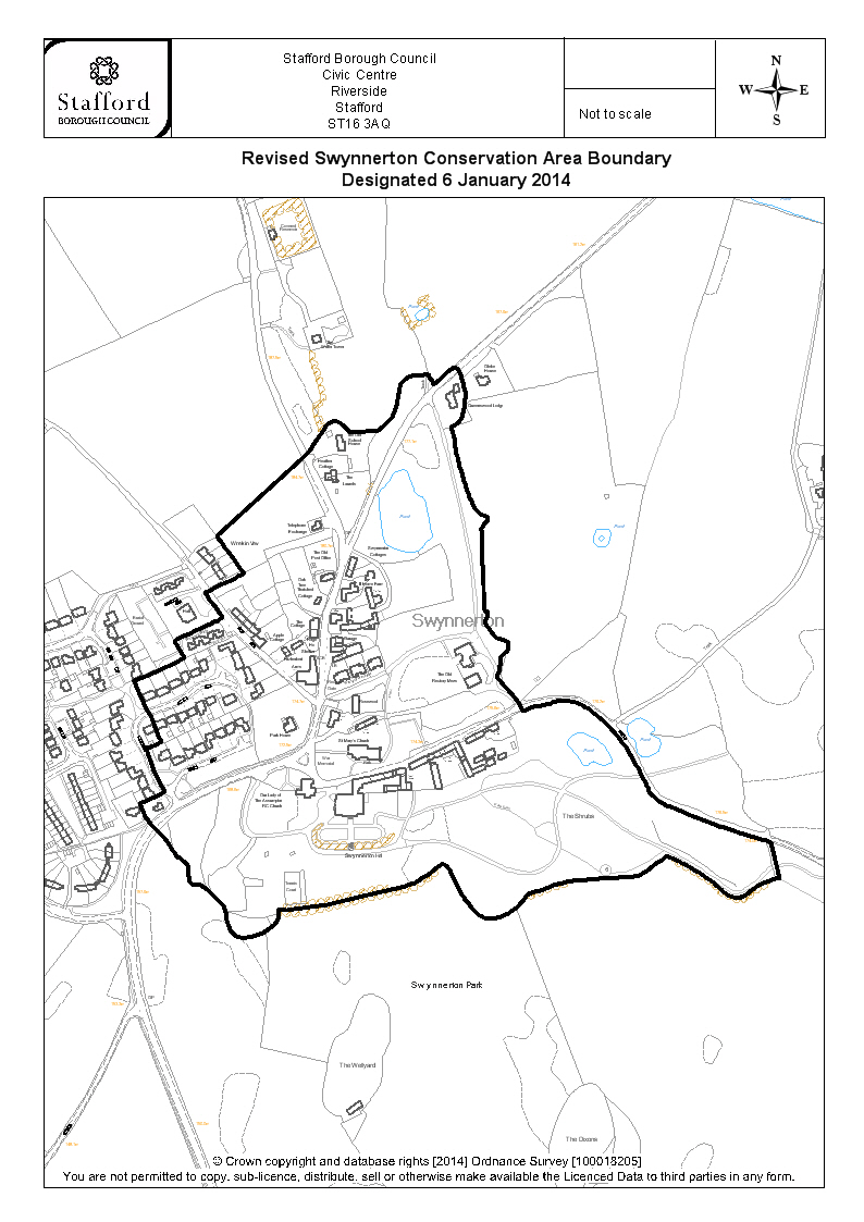
Swynnerton
| Field | Value | Fact links |
|---|---|---|
| CURIE | conservation-area:28 | no fact link |
| Prefix | conservation-area | Facts |
| Reference | 28 | Facts |
| Name | Swynnerton | Facts |
| Quality | Authoritative: We have some data from the authoritative source | no fact link |
| Dataset | Conservation area | no fact link |
| Organisation | Stafford Borough Council | no fact link |
| Start date | 1970-03-03 | Facts |
| End date | Facts | |
| Entry date | 2014-01-06 | Facts |
| Typology | geography | no fact link |
| Geometry |
MULTIPOLYGON (((-2.216207 52.915751, -2.215857 52.915652, -2.215509 52.915515, -2.215398 52.91546, -2.215349 52.915423, -2.215187 52.915357, -2.215088 52.915333, -2.214989 52.915345, -2.214819 52.915412, -2.214736 52.915453, -2.214657 52.915477, -2.214395 52.91553, -2.214533 52.915891, -2.21467 52.915909, -2.215278 52.916024, -2.216069 52.916206, -2.216242 52.916249, -2.216478 52.916349, -2.216694 52.916624, -2.216868 52.916813, -2.217039 52.916941, -2.2172 52.917049, -2.217485 52.917192, -2.217681 52.917255, -2.21787 52.917268, -2.218024 52.917262, -2.218432 52.9172, -2.218575 52.917164, -2.218594 52.917211, -2.218638 52.917256, -2.218703 52.917308, -2.218973 52.917491, -2.218932 52.917572, -2.21891 52.917638, -2.218921 52.91768, -2.218898 52.917712, -2.218814 52.917751, -2.218785 52.917782, -2.218778 52.91783, -2.218829 52.91785, -2.219009 52.917886, -2.219125 52.91799, -2.219152 52.918023, -2.219155 52.918052, -2.219129 52.918087, -2.21911 52.918132, -2.219164 52.918141, -2.219199 52.91854, -2.219212 52.918876, -2.219225 52.918978, -2.219165 52.919032, -2.219127 52.919094, -2.219197 52.919105, -2.219281 52.919146, -2.21936 52.919201, -2.219454 52.919334, -2.219586 52.919587, -2.219596 52.919643, -2.219627 52.919693, -2.219669 52.919844, -2.219722 52.919975, -2.219617 52.919996, -2.219559 52.92005, -2.219511 52.92018, -2.219522 52.920202, -2.219507 52.920239, -2.219504 52.920282, -2.219552 52.920425, -2.219609 52.920512, -2.219702 52.920561, -2.22001 52.920394, -2.220096 52.920493, -2.220415 52.920463, -2.220516 52.920424, -2.220565 52.920389, -2.22059 52.920358, -2.220616 52.92023, -2.220658 52.920111, -2.220694 52.920071, -2.220774 52.920014, -2.220945 52.919932, -2.221385 52.919921, -2.221517 52.920002, -2.221625 52.920031, -2.22169 52.920022, -2.221762 52.919991, -2.222068 52.919718, -2.222142 52.919671, -2.223536 52.918882, -2.223105 52.918516, -2.223638 52.91835, -2.223344 52.918121, -2.223471 52.918063, -2.223569 52.918032, -2.224221 52.917856, -2.22404 52.917675, -2.224857 52.917449, -2.224609 52.917116, -2.224527 52.916991, -2.224406 52.916838, -2.224667 52.916784, -2.224579 52.916674, -2.224539 52.916585, -2.224531 52.916545, -2.22444 52.916456, -2.22432 52.916373, -2.22479 52.916242, -2.224596 52.91604, -2.22439 52.915919, -2.224317 52.915857, -2.22425 52.915784, -2.224217 52.915732, -2.224174 52.915702, -2.224062 52.915651, -2.224009 52.915613, -2.223979 52.915512, -2.223972 52.91546, -2.223951 52.91544, -2.223908 52.915423, -2.223851 52.915421, -2.223789 52.915435, -2.22351 52.915278, -2.223407 52.915191, -2.223369 52.915071, -2.22332 52.914994, -2.223243 52.914948, -2.223159 52.914913, -2.223036 52.914919, -2.222859 52.914945, -2.2227 52.914999, -2.222637 52.915036, -2.222595 52.915045, -2.222555 52.915078, -2.222499 52.915139, -2.222526 52.915186, -2.222005 52.915227, -2.221741 52.915257, -2.220473 52.915457, -2.220308 52.915494, -2.219922 52.915651, -2.219875 52.915664, -2.219777 52.915617, -2.219712 52.915559, -2.219654 52.915476, -2.21959 52.915407, -2.219472 52.915299, -2.219353 52.915207, -2.219261 52.915157, -2.219174 52.915132, -2.219078 52.915124, -2.218979 52.915127, -2.218783 52.915181, -2.218612 52.915254, -2.218479 52.915358, -2.218169 52.915428, -2.218005 52.915462, -2.217649 52.915504, -2.216727 52.915543, -2.216624 52.915565, -2.216207 52.915751)))
|
Facts |
| Point |
POINT (-2.220734 52.917203)
|
Facts |
| Document url | https://www.staffordbc.gov.uk/sites/default/files/cme/DocMan1/Planning%20Policy/Conservation/Conservation%20Areas/Conservation%20Area%20Boundaries/Swynnerton-CA-boundary-2013.jpg | Facts |
| Designation date | 1970-03-03 | Facts |
| Documentation url | https://www.staffordbc.gov.uk/conservation-areas-list | Facts |
Available Code Snippets:
{
        "entry-date": "2014-01-06",
        "start-date": "1970-03-03",
        "end-date": "",
        "entity": 44015893,
        "name": "Swynnerton",
        "dataset": "conservation-area",
        "typology": "geography",
        "reference": "28",
        "prefix": "conservation-area",
        "organisation-entity": "315",
        "geometry": "MULTIPOLYGON (((-2.216207 52.915751, -2.215857 52.915652, -2.215509 52.915515, -2.215398 52.91546, -2.215349 52.915423, -2.215187 52.915357, -2.215088 52.915333, -2.214989 52.915345, -2.214819 52.915412, -2.214736 52.915453, -2.214657 52.915477, -2.214395 52.91553, -2.214533 52.915891, -2.21467 52.915909, -2.215278 52.916024, -2.216069 52.916206, -2.216242 52.916249, -2.216478 52.916349, -2.216694 52.916624, -2.216868 52.916813, -2.217039 52.916941, -2.2172 52.917049, -2.217485 52.917192, -2.217681 52.917255, -2.21787 52.917268, -2.218024 52.917262, -2.218432 52.9172, -2.218575 52.917164, -2.218594 52.917211, -2.218638 52.917256, -2.218703 52.917308, -2.218973 52.917491, -2.218932 52.917572, -2.21891 52.917638, -2.218921 52.91768, -2.218898 52.917712, -2.218814 52.917751, -2.218785 52.917782, -2.218778 52.91783, -2.218829 52.91785, -2.219009 52.917886, -2.219125 52.91799, -2.219152 52.918023, -2.219155 52.918052, -2.219129 52.918087, -2.21911 52.918132, -2.219164 52.918141, -2.219199 52.91854, -2.219212 52.918876, -2.219225 52.918978, -2.219165 52.919032, -2.219127 52.919094, -2.219197 52.919105, -2.219281 52.919146, -2.21936 52.919201, -2.219454 52.919334, -2.219586 52.919587, -2.219596 52.919643, -2.219627 52.919693, -2.219669 52.919844, -2.219722 52.919975, -2.219617 52.919996, -2.219559 52.92005, -2.219511 52.92018, -2.219522 52.920202, -2.219507 52.920239, -2.219504 52.920282, -2.219552 52.920425, -2.219609 52.920512, -2.219702 52.920561, -2.22001 52.920394, -2.220096 52.920493, -2.220415 52.920463, -2.220516 52.920424, -2.220565 52.920389, -2.22059 52.920358, -2.220616 52.92023, -2.220658 52.920111, -2.220694 52.920071, -2.220774 52.920014, -2.220945 52.919932, -2.221385 52.919921, -2.221517 52.920002, -2.221625 52.920031, -2.22169 52.920022, -2.221762 52.919991, -2.222068 52.919718, -2.222142 52.919671, -2.223536 52.918882, -2.223105 52.918516, -2.223638 52.91835, -2.223344 52.918121, -2.223471 52.918063, -2.223569 52.918032, -2.224221 52.917856, -2.22404 52.917675, -2.224857 52.917449, -2.224609 52.917116, -2.224527 52.916991, -2.224406 52.916838, -2.224667 52.916784, -2.224579 52.916674, -2.224539 52.916585, -2.224531 52.916545, -2.22444 52.916456, -2.22432 52.916373, -2.22479 52.916242, -2.224596 52.91604, -2.22439 52.915919, -2.224317 52.915857, -2.22425 52.915784, -2.224217 52.915732, -2.224174 52.915702, -2.224062 52.915651, -2.224009 52.915613, -2.223979 52.915512, -2.223972 52.91546, -2.223951 52.91544, -2.223908 52.915423, -2.223851 52.915421, -2.223789 52.915435, -2.22351 52.915278, -2.223407 52.915191, -2.223369 52.915071, -2.22332 52.914994, -2.223243 52.914948, -2.223159 52.914913, -2.223036 52.914919, -2.222859 52.914945, -2.2227 52.914999, -2.222637 52.915036, -2.222595 52.915045, -2.222555 52.915078, -2.222499 52.915139, -2.222526 52.915186, -2.222005 52.915227, -2.221741 52.915257, -2.220473 52.915457, -2.220308 52.915494, -2.219922 52.915651, -2.219875 52.915664, -2.219777 52.915617, -2.219712 52.915559, -2.219654 52.915476, -2.21959 52.915407, -2.219472 52.915299, -2.219353 52.915207, -2.219261 52.915157, -2.219174 52.915132, -2.219078 52.915124, -2.218979 52.915127, -2.218783 52.915181, -2.218612 52.915254, -2.218479 52.915358, -2.218169 52.915428, -2.218005 52.915462, -2.217649 52.915504, -2.216727 52.915543, -2.216624 52.915565, -2.216207 52.915751)))",
        "point": "POINT (-2.220734 52.917203)",
        "quality": "authoritative",
        "document-url": "https://www.staffordbc.gov.uk/sites/default/files/cme/DocMan1/Planning%20Policy/Conservation/Conservation%20Areas/Conservation%20Area%20Boundaries/Swynnerton-CA-boundary-2013.jpg",
        "designation-date": "1970-03-03",
        "documentation-url": "https://www.staffordbc.gov.uk/conservation-areas-list"
}Loading...© Historic England 2026. Contains Ordnance Survey data © Crown copyright and database right 2026. The Historic England GIS Data contained in this material was obtained on [date]. The most publicly available up to date Historic England GIS Data can be obtained from HistoricEngland.org.uk.
Licensed under the Open Government Licence v.3.0.
Geographical area
Help improve this data
Give feedback on this dataset, or email your questions and corrections to digitalland@communities.gov.uk.