Conservation area
Gnosall
| Field | Value | Fact links |
|---|---|---|
| CURIE | conservation-area:23 | no fact link |
| Prefix | conservation-area | Facts |
| Reference | 23 | Facts |
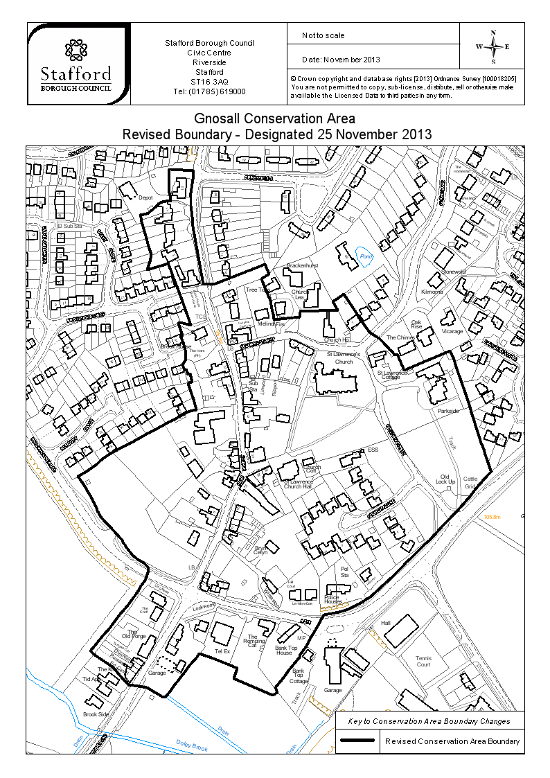
| Name | Gnosall | Facts |
| Quality | Authoritative: We have some data from the authoritative source | no fact link |
| Dataset | Conservation area | no fact link |
| Organisation | Stafford Borough Council | no fact link |
| Start date | 1971-02-24 | Facts |
| End date | Facts | |
| Entry date | 2013-11-25 | Facts |
| Typology | geography | no fact link |
| Geometry |
MULTIPOLYGON (((-2.255304 52.78704, -2.255291 52.787113, -2.255633 52.787125, -2.255637 52.787003, -2.255626 52.786902, -2.255613 52.78685, -2.255677 52.786849, -2.255727 52.786843, -2.255745 52.786839, -2.255776 52.786828, -2.255794 52.786819, -2.255927 52.786746, -2.256039 52.786728, -2.256019 52.786673, -2.255988 52.786611, -2.25592 52.786465, -2.255881 52.786391, -2.255943 52.786262, -2.255676 52.786308, -2.255643 52.786316, -2.255401 52.785926, -2.25532 52.785789, -2.25547 52.78581, -2.255496 52.785805, -2.255437 52.785702, -2.255464 52.785696, -2.255432 52.785643, -2.255387 52.785554, -2.255388 52.785496, -2.255439 52.785453, -2.25541 52.785401, -2.255381 52.785406, -2.255362 52.785369, -2.255332 52.785375, -2.255294 52.785303, -2.255353 52.785292, -2.255237 52.785067, -2.255285 52.78506, -2.255353 52.785046, -2.25555 52.784981, -2.255669 52.784945, -2.255736 52.784921, -2.255823 52.784894, -2.255945 52.784853, -2.256431 52.784696, -2.256593 52.784625, -2.25665 52.784595, -2.2567 52.784571, -2.256805 52.784526, -2.256905 52.784492, -2.256823 52.784417, -2.256726 52.784316, -2.256617 52.78418, -2.256577 52.784138, -2.256307 52.783964, -2.256274 52.783941, -2.256257 52.783917, -2.256217 52.783883, -2.256212 52.783874, -2.256136 52.783819, -2.256065 52.783783, -2.255974 52.783753, -2.255917 52.783715, -2.255909 52.783686, -2.255924 52.78365, -2.255955 52.783604, -2.256062 52.783502, -2.256243 52.783355, -2.256456 52.783194, -2.256548 52.783127, -2.256725 52.782994, -2.256676 52.782968, -2.256402 52.782854, -2.256185 52.782706, -2.25592 52.782682, -2.255815 52.78264, -2.255776 52.782627, -2.255693 52.782603, -2.255663 52.782598, -2.255403 52.782811, -2.255367 52.782839, -2.25531 52.782879, -2.255219 52.782947, -2.255185 52.782975, -2.255015 52.782939, -2.254769 52.78288, -2.254653 52.78285, -2.254694 52.782762, -2.254144 52.782624, -2.254076 52.782648, -2.254114 52.782684, -2.253808 52.782921, -2.253762 52.782955, -2.253761 52.782975, -2.253668 52.783043, -2.253539 52.783195, -2.25343 52.783309, -2.253209 52.783335, -2.253081 52.783359, -2.252926 52.783406, -2.25278 52.783464, -2.252465 52.783641, -2.251926 52.783963, -2.251834 52.78402, -2.251763 52.784067, -2.251678 52.784126, -2.251509 52.784234, -2.25137 52.784334, -2.251274 52.784408, -2.251199 52.784456, -2.251066 52.784548, -2.251078 52.784553, -2.251151 52.784687, -2.25121 52.784791, -2.251231 52.784832, -2.251291 52.784938, -2.251351 52.785049, -2.251375 52.785097, -2.251567 52.785442, -2.251612 52.785517, -2.251609 52.785518, -2.251657 52.785576, -2.251727 52.785557, -2.251732 52.785561, -2.252028 52.785483, -2.252303 52.785407, -2.252404 52.785545, -2.252442 52.785542, -2.252467 52.78557, -2.252502 52.785582, -2.252658 52.785681, -2.252799 52.785735, -2.253162 52.786062, -2.253313 52.785997, -2.25325 52.785925, -2.253773 52.78591, -2.253784 52.785861, -2.254144 52.785838, -2.254196 52.786, -2.254328 52.786189, -2.254214 52.786229, -2.254281 52.786316, -2.254998 52.786137, -2.255148 52.786138, -2.25524 52.786435, -2.255297 52.786631, -2.255306 52.786718, -2.255327 52.78681, -2.255333 52.786887, -2.255304 52.78704)))
|
Facts |
| Point |
POINT (-2.254141 52.784505)
|
Facts |
| Document url | https://www.staffordbc.gov.uk/sites/default/files/cme/DocMan1/Planning%20Policy/Conservation/Conservation%20Areas/Conservation%20Area%20Boundaries/Gnosall-CA-boundary-2013.png | Facts |
| Designation date | 1971-02-24 | Facts |
| Documentation url | https://www.staffordbc.gov.uk/conservation-areas-list | Facts |
Available Code Snippets:
{
        "entry-date": "2013-11-25",
        "start-date": "1971-02-24",
        "end-date": "",
        "entity": 44015889,
        "name": "Gnosall",
        "dataset": "conservation-area",
        "typology": "geography",
        "reference": "23",
        "prefix": "conservation-area",
        "organisation-entity": "315",
        "geometry": "MULTIPOLYGON (((-2.255304 52.78704, -2.255291 52.787113, -2.255633 52.787125, -2.255637 52.787003, -2.255626 52.786902, -2.255613 52.78685, -2.255677 52.786849, -2.255727 52.786843, -2.255745 52.786839, -2.255776 52.786828, -2.255794 52.786819, -2.255927 52.786746, -2.256039 52.786728, -2.256019 52.786673, -2.255988 52.786611, -2.25592 52.786465, -2.255881 52.786391, -2.255943 52.786262, -2.255676 52.786308, -2.255643 52.786316, -2.255401 52.785926, -2.25532 52.785789, -2.25547 52.78581, -2.255496 52.785805, -2.255437 52.785702, -2.255464 52.785696, -2.255432 52.785643, -2.255387 52.785554, -2.255388 52.785496, -2.255439 52.785453, -2.25541 52.785401, -2.255381 52.785406, -2.255362 52.785369, -2.255332 52.785375, -2.255294 52.785303, -2.255353 52.785292, -2.255237 52.785067, -2.255285 52.78506, -2.255353 52.785046, -2.25555 52.784981, -2.255669 52.784945, -2.255736 52.784921, -2.255823 52.784894, -2.255945 52.784853, -2.256431 52.784696, -2.256593 52.784625, -2.25665 52.784595, -2.2567 52.784571, -2.256805 52.784526, -2.256905 52.784492, -2.256823 52.784417, -2.256726 52.784316, -2.256617 52.78418, -2.256577 52.784138, -2.256307 52.783964, -2.256274 52.783941, -2.256257 52.783917, -2.256217 52.783883, -2.256212 52.783874, -2.256136 52.783819, -2.256065 52.783783, -2.255974 52.783753, -2.255917 52.783715, -2.255909 52.783686, -2.255924 52.78365, -2.255955 52.783604, -2.256062 52.783502, -2.256243 52.783355, -2.256456 52.783194, -2.256548 52.783127, -2.256725 52.782994, -2.256676 52.782968, -2.256402 52.782854, -2.256185 52.782706, -2.25592 52.782682, -2.255815 52.78264, -2.255776 52.782627, -2.255693 52.782603, -2.255663 52.782598, -2.255403 52.782811, -2.255367 52.782839, -2.25531 52.782879, -2.255219 52.782947, -2.255185 52.782975, -2.255015 52.782939, -2.254769 52.78288, -2.254653 52.78285, -2.254694 52.782762, -2.254144 52.782624, -2.254076 52.782648, -2.254114 52.782684, -2.253808 52.782921, -2.253762 52.782955, -2.253761 52.782975, -2.253668 52.783043, -2.253539 52.783195, -2.25343 52.783309, -2.253209 52.783335, -2.253081 52.783359, -2.252926 52.783406, -2.25278 52.783464, -2.252465 52.783641, -2.251926 52.783963, -2.251834 52.78402, -2.251763 52.784067, -2.251678 52.784126, -2.251509 52.784234, -2.25137 52.784334, -2.251274 52.784408, -2.251199 52.784456, -2.251066 52.784548, -2.251078 52.784553, -2.251151 52.784687, -2.25121 52.784791, -2.251231 52.784832, -2.251291 52.784938, -2.251351 52.785049, -2.251375 52.785097, -2.251567 52.785442, -2.251612 52.785517, -2.251609 52.785518, -2.251657 52.785576, -2.251727 52.785557, -2.251732 52.785561, -2.252028 52.785483, -2.252303 52.785407, -2.252404 52.785545, -2.252442 52.785542, -2.252467 52.78557, -2.252502 52.785582, -2.252658 52.785681, -2.252799 52.785735, -2.253162 52.786062, -2.253313 52.785997, -2.25325 52.785925, -2.253773 52.78591, -2.253784 52.785861, -2.254144 52.785838, -2.254196 52.786, -2.254328 52.786189, -2.254214 52.786229, -2.254281 52.786316, -2.254998 52.786137, -2.255148 52.786138, -2.25524 52.786435, -2.255297 52.786631, -2.255306 52.786718, -2.255327 52.78681, -2.255333 52.786887, -2.255304 52.78704)))",
        "point": "POINT (-2.254141 52.784505)",
        "quality": "authoritative",
        "document-url": "https://www.staffordbc.gov.uk/sites/default/files/cme/DocMan1/Planning%20Policy/Conservation/Conservation%20Areas/Conservation%20Area%20Boundaries/Gnosall-CA-boundary-2013.png",
        "designation-date": "1971-02-24",
        "documentation-url": "https://www.staffordbc.gov.uk/conservation-areas-list",
        "organisation-curie": "local-authority:STA"
}Loading...© Historic England 2026. Contains Ordnance Survey data © Crown copyright and database right 2026. The Historic England GIS Data contained in this material was obtained on [date]. The most publicly available up to date Historic England GIS Data can be obtained from HistoricEngland.org.uk.
Licensed under the Open Government Licence v.3.0.
Geographical area
Help improve this data
Give feedback on this dataset, or email your questions and corrections to digitalland@communities.gov.uk.