Conservation area
Walton-on-the-Hill
| Field | Value | Fact links |
|---|---|---|
| CURIE | conservation-area:18 | no fact link |
| Prefix | conservation-area | Facts |
| Reference | 18 | Facts |
| Name | Walton-on-the-Hill | Facts |
| Quality | Authoritative: We have some data from the authoritative source | no fact link |
| Dataset | Conservation area | no fact link |
| Organisation | Stafford Borough Council | no fact link |
| Start date | 1977-03-03 | Facts |
| End date | Facts | |
| Entry date | 2017-03-06 | Facts |
| Typology | geography | no fact link |
| Geometry |
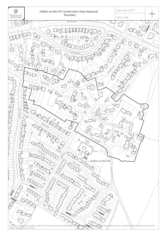
MULTIPOLYGON (((-2.065453 52.78718, -2.065557 52.787059, -2.065715 52.78688, -2.065773 52.786829, -2.066207 52.786977, -2.066283 52.786985, -2.066472 52.787025, -2.066805 52.787084, -2.066801 52.787097, -2.066819 52.787118, -2.066841 52.78713, -2.066863 52.787136, -2.066885 52.787134, -2.066889 52.787119, -2.067031 52.787131, -2.06705 52.78713, -2.06722 52.787145, -2.067373 52.787172, -2.067595 52.7872, -2.067595 52.787204, -2.067789 52.787234, -2.067868 52.786957, -2.06785 52.786776, -2.067916 52.786616, -2.06741 52.786537, -2.067529 52.786297, -2.067582 52.786196, -2.067435 52.786172, -2.06726 52.786141, -2.067345 52.786047, -2.067014 52.785999, -2.066982 52.785989, -2.066072 52.785647, -2.065933 52.785592, -2.065662 52.785492, -2.0656 52.785558, -2.064943 52.785442, -2.065098 52.785279, -2.065172 52.785198, -2.065102 52.785176, -2.064867 52.785108, -2.064671 52.785038, -2.064387 52.784946, -2.063672 52.784702, -2.063549 52.784644, -2.063478 52.784601, -2.063454 52.784558, -2.063423 52.784482, -2.063403 52.784388, -2.063279 52.784374, -2.063184 52.784361, -2.062792 52.784284, -2.062711 52.784236, -2.062677 52.784227, -2.062624 52.784228, -2.062525 52.784238, -2.062 52.784215, -2.06164 52.784885, -2.061576 52.784873, -2.061473 52.785056, -2.061733 52.78511, -2.0615 52.785531, -2.061527 52.785539, -2.061609 52.785558, -2.061584 52.78561, -2.061535 52.785698, -2.061519 52.785745, -2.061532 52.785765, -2.061558 52.78579, -2.061569 52.785831, -2.061523 52.785861, -2.061438 52.785898, -2.06138 52.785916, -2.061339 52.785926, -2.0613 52.785941, -2.061276 52.785956, -2.061259 52.785976, -2.061249 52.786002, -2.06128 52.786025, -2.061351 52.786062, -2.061392 52.786067, -2.061443 52.786071, -2.061523 52.786069, -2.06166 52.786057, -2.061733 52.786053, -2.061978 52.786147, -2.062325 52.786283, -2.062587 52.786382, -2.062745 52.786257, -2.062859 52.786172, -2.062952 52.786129, -2.063232 52.786279, -2.063056 52.786413, -2.063506 52.786601, -2.063557 52.786571, -2.063595 52.78656, -2.063934 52.786493, -2.064038 52.786824, -2.06404 52.786862, -2.064039 52.786898, -2.06415 52.786883, -2.064461 52.786796, -2.06477 52.786994, -2.064789 52.787031, -2.064981 52.787096, -2.065361 52.78716, -2.065453 52.78718)))
|
Facts |
| Point |
POINT (-2.064328 52.78585)
|
Facts |
| Document url | https://www.staffordbc.gov.uk/sites/default/files/cme/DocMan1/Planning%20Policy/Conservation/Conservation%20Areas/Conservation%20Area%20Boundaries/Walton-on-the-Hill-Conservation-Area-Boundary-06-03-2017_0.jpg | Facts |
| Designation date | 1977-03-03 | Facts |
| Documentation url | https://www.staffordbc.gov.uk/conservation-areas-list | Facts |
Available Code Snippets:
{
        "entry-date": "2017-03-06",
        "start-date": "1977-03-03",
        "end-date": "",
        "entity": 44015888,
        "name": "Walton-on-the-Hill",
        "dataset": "conservation-area",
        "typology": "geography",
        "reference": "18",
        "prefix": "conservation-area",
        "organisation-entity": "315",
        "geometry": "MULTIPOLYGON (((-2.065453 52.78718, -2.065557 52.787059, -2.065715 52.78688, -2.065773 52.786829, -2.066207 52.786977, -2.066283 52.786985, -2.066472 52.787025, -2.066805 52.787084, -2.066801 52.787097, -2.066819 52.787118, -2.066841 52.78713, -2.066863 52.787136, -2.066885 52.787134, -2.066889 52.787119, -2.067031 52.787131, -2.06705 52.78713, -2.06722 52.787145, -2.067373 52.787172, -2.067595 52.7872, -2.067595 52.787204, -2.067789 52.787234, -2.067868 52.786957, -2.06785 52.786776, -2.067916 52.786616, -2.06741 52.786537, -2.067529 52.786297, -2.067582 52.786196, -2.067435 52.786172, -2.06726 52.786141, -2.067345 52.786047, -2.067014 52.785999, -2.066982 52.785989, -2.066072 52.785647, -2.065933 52.785592, -2.065662 52.785492, -2.0656 52.785558, -2.064943 52.785442, -2.065098 52.785279, -2.065172 52.785198, -2.065102 52.785176, -2.064867 52.785108, -2.064671 52.785038, -2.064387 52.784946, -2.063672 52.784702, -2.063549 52.784644, -2.063478 52.784601, -2.063454 52.784558, -2.063423 52.784482, -2.063403 52.784388, -2.063279 52.784374, -2.063184 52.784361, -2.062792 52.784284, -2.062711 52.784236, -2.062677 52.784227, -2.062624 52.784228, -2.062525 52.784238, -2.062 52.784215, -2.06164 52.784885, -2.061576 52.784873, -2.061473 52.785056, -2.061733 52.78511, -2.0615 52.785531, -2.061527 52.785539, -2.061609 52.785558, -2.061584 52.78561, -2.061535 52.785698, -2.061519 52.785745, -2.061532 52.785765, -2.061558 52.78579, -2.061569 52.785831, -2.061523 52.785861, -2.061438 52.785898, -2.06138 52.785916, -2.061339 52.785926, -2.0613 52.785941, -2.061276 52.785956, -2.061259 52.785976, -2.061249 52.786002, -2.06128 52.786025, -2.061351 52.786062, -2.061392 52.786067, -2.061443 52.786071, -2.061523 52.786069, -2.06166 52.786057, -2.061733 52.786053, -2.061978 52.786147, -2.062325 52.786283, -2.062587 52.786382, -2.062745 52.786257, -2.062859 52.786172, -2.062952 52.786129, -2.063232 52.786279, -2.063056 52.786413, -2.063506 52.786601, -2.063557 52.786571, -2.063595 52.78656, -2.063934 52.786493, -2.064038 52.786824, -2.06404 52.786862, -2.064039 52.786898, -2.06415 52.786883, -2.064461 52.786796, -2.06477 52.786994, -2.064789 52.787031, -2.064981 52.787096, -2.065361 52.78716, -2.065453 52.78718)))",
        "point": "POINT (-2.064328 52.78585)",
        "quality": "authoritative",
        "document-url": "https://www.staffordbc.gov.uk/sites/default/files/cme/DocMan1/Planning%20Policy/Conservation/Conservation%20Areas/Conservation%20Area%20Boundaries/Walton-on-the-Hill-Conservation-Area-Boundary-06-03-2017_0.jpg",
        "designation-date": "1977-03-03",
        "documentation-url": "https://www.staffordbc.gov.uk/conservation-areas-list",
        "organisation-curie": "local-authority:STA"
}Loading...© Historic England 2026. Contains Ordnance Survey data © Crown copyright and database right 2026. The Historic England GIS Data contained in this material was obtained on [date]. The most publicly available up to date Historic England GIS Data can be obtained from HistoricEngland.org.uk.
Licensed under the Open Government Licence v.3.0.
Geographical area
Help improve this data
Give feedback on this dataset, or email your questions and corrections to digitalland@communities.gov.uk.