Conservation area
Offleybrook
| Field | Value | Fact links |
|---|---|---|
| CURIE | conservation-area:11 | no fact link |
| Prefix | conservation-area | Facts |
| Reference | 11 | Facts |
| Name | Offleybrook | Facts |
| Quality | Authoritative: We have some data from the authoritative source | no fact link |
| Dataset | Conservation area | no fact link |
| Organisation | Stafford Borough Council | no fact link |
| Start date | 1993-06-10 | Facts |
| End date | Facts | |
| Entry date | 2015-07-20 | Facts |
| Typology | geography | no fact link |
| Geometry |
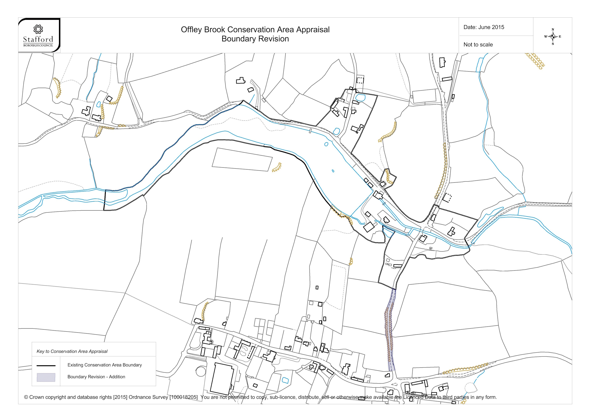
MULTIPOLYGON (((-2.325586 52.869374, -2.326223 52.869429, -2.326226 52.869494, -2.326318 52.869471, -2.326375 52.869481, -2.326535 52.869481, -2.326676 52.869319, -2.326742 52.869326, -2.326785 52.869312, -2.326812 52.869323, -2.326975 52.869166, -2.326968 52.869106, -2.327407 52.86882, -2.328142 52.868923, -2.328152 52.868902, -2.328721 52.868948, -2.328821 52.868976, -2.329021 52.869065, -2.329549 52.869276, -2.329625 52.869221, -2.329862 52.869134, -2.33026 52.869038, -2.330476 52.868949, -2.330677 52.86885, -2.330747 52.868839, -2.330937 52.868836, -2.331079 52.8688, -2.331193 52.868735, -2.331306 52.868657, -2.331434 52.868586, -2.331559 52.868498, -2.331836 52.868377, -2.331871 52.868351, -2.331982 52.868225, -2.33211 52.86813, -2.33229 52.868025, -2.33254 52.86784, -2.332798 52.867728, -2.333043 52.867697, -2.333245 52.867655, -2.333404 52.867652, -2.333608 52.867665, -2.333627 52.867474, -2.33366 52.8673, -2.333396 52.867303, -2.333257 52.867317, -2.332967 52.867408, -2.332508 52.86758, -2.332486 52.867559, -2.332025 52.867865, -2.331902 52.867933, -2.331748 52.867973, -2.331159 52.868349, -2.33106 52.868394, -2.330714 52.868505, -2.330607 52.868515, -2.330541 52.868537, -2.330286 52.868569, -2.329826 52.868562, -2.329287 52.868492, -2.3289 52.86845, -2.328741 52.868443, -2.328617 52.868397, -2.328341 52.868356, -2.328059 52.8683, -2.327823 52.868204, -2.327756 52.86817, -2.327708 52.86813, -2.327374 52.867738, -2.327202 52.867574, -2.327097 52.86749, -2.326922 52.867368, -2.326649 52.867207, -2.326515 52.867214, -2.326438 52.867173, -2.326271 52.866976, -2.325847 52.866792, -2.325735 52.866762, -2.325588 52.866743, -2.325365 52.866744, -2.325346 52.866769, -2.325352 52.866858, -2.325384 52.866908, -2.325423 52.86695, -2.325408 52.866959, -2.325412 52.867055, -2.325275 52.867004, -2.325049 52.866947, -2.325182 52.866826, -2.325253 52.866742, -2.32533 52.866622, -2.325361 52.866537, -2.325382 52.866365, -2.325414 52.866317, -2.325509 52.866128, -2.325538 52.86603, -2.325451 52.866019, -2.325128 52.865928, -2.325172 52.865782, -2.325353 52.865475, -2.32533 52.865325, -2.325341 52.865259, -2.325339 52.86521, -2.325323 52.865201, -2.325326 52.865097, -2.325288 52.86502, -2.325271 52.864961, -2.325254 52.86483, -2.325242 52.86463, -2.325214 52.864454, -2.32502 52.864466, -2.325071 52.864599, -2.325103 52.86472, -2.325096 52.864931, -2.325131 52.865155, -2.325132 52.86531, -2.325147 52.865399, -2.325141 52.865417, -2.325145 52.8655, -2.325034 52.865745, -2.325018 52.865856, -2.325019 52.865907, -2.324999 52.866021, -2.32491 52.866157, -2.324803 52.866262, -2.324613 52.866489, -2.324465 52.866471, -2.324416 52.86649, -2.324386 52.866513, -2.324336 52.86653, -2.324239 52.866536, -2.324157 52.866525, -2.324117 52.866471, -2.323955 52.866457, -2.323794 52.866474, -2.323657 52.866473, -2.323357 52.866515, -2.323013 52.866539, -2.322974 52.86655, -2.322855 52.866598, -2.32284 52.866628, -2.322861 52.866666, -2.322995 52.866816, -2.322992 52.866829, -2.322899 52.866917, -2.322604 52.867158, -2.323298 52.867288, -2.323729 52.86736, -2.323767 52.867386, -2.323754 52.867398, -2.323905 52.867431, -2.32405 52.867249, -2.324173 52.867153, -2.324249 52.867121, -2.32429 52.867111, -2.324352 52.867114, -2.324606 52.86718, -2.324732 52.867234, -2.32493 52.867352, -2.325142 52.867513, -2.325367 52.867702, -2.325152 52.86777, -2.32502 52.867917, -2.325206 52.86798, -2.325244 52.868068, -2.325359 52.868057, -2.325473 52.867887, -2.325472 52.867855, -2.325521 52.867825, -2.325975 52.868097, -2.32612 52.868202, -2.326358 52.868343, -2.326092 52.868646, -2.325723 52.869147, -2.325586 52.869374)))
|
Facts |
| Point |
POINT (-2.327007 52.867822)
|
Facts |
| Document url | https://www.staffordbc.gov.uk/sites/default/files/cme/DocMan1/Planning%20Policy/Conservation/Conservation%20Areas/Conservation%20Area%20Boundaries/Offley-Brook-Conservation-Area-boundary-2-7-15_0.jpg | Facts |
| Designation date | 1993-06-10 | Facts |
| Documentation url | https://www.staffordbc.gov.uk/conservation-areas-list | Facts |
Available Code Snippets:
{
        "entry-date": "2015-07-20",
        "start-date": "1993-06-10",
        "end-date": "",
        "entity": 44015874,
        "name": "Offleybrook",
        "dataset": "conservation-area",
        "typology": "geography",
        "reference": "11",
        "prefix": "conservation-area",
        "organisation-entity": "315",
        "geometry": "MULTIPOLYGON (((-2.325586 52.869374, -2.326223 52.869429, -2.326226 52.869494, -2.326318 52.869471, -2.326375 52.869481, -2.326535 52.869481, -2.326676 52.869319, -2.326742 52.869326, -2.326785 52.869312, -2.326812 52.869323, -2.326975 52.869166, -2.326968 52.869106, -2.327407 52.86882, -2.328142 52.868923, -2.328152 52.868902, -2.328721 52.868948, -2.328821 52.868976, -2.329021 52.869065, -2.329549 52.869276, -2.329625 52.869221, -2.329862 52.869134, -2.33026 52.869038, -2.330476 52.868949, -2.330677 52.86885, -2.330747 52.868839, -2.330937 52.868836, -2.331079 52.8688, -2.331193 52.868735, -2.331306 52.868657, -2.331434 52.868586, -2.331559 52.868498, -2.331836 52.868377, -2.331871 52.868351, -2.331982 52.868225, -2.33211 52.86813, -2.33229 52.868025, -2.33254 52.86784, -2.332798 52.867728, -2.333043 52.867697, -2.333245 52.867655, -2.333404 52.867652, -2.333608 52.867665, -2.333627 52.867474, -2.33366 52.8673, -2.333396 52.867303, -2.333257 52.867317, -2.332967 52.867408, -2.332508 52.86758, -2.332486 52.867559, -2.332025 52.867865, -2.331902 52.867933, -2.331748 52.867973, -2.331159 52.868349, -2.33106 52.868394, -2.330714 52.868505, -2.330607 52.868515, -2.330541 52.868537, -2.330286 52.868569, -2.329826 52.868562, -2.329287 52.868492, -2.3289 52.86845, -2.328741 52.868443, -2.328617 52.868397, -2.328341 52.868356, -2.328059 52.8683, -2.327823 52.868204, -2.327756 52.86817, -2.327708 52.86813, -2.327374 52.867738, -2.327202 52.867574, -2.327097 52.86749, -2.326922 52.867368, -2.326649 52.867207, -2.326515 52.867214, -2.326438 52.867173, -2.326271 52.866976, -2.325847 52.866792, -2.325735 52.866762, -2.325588 52.866743, -2.325365 52.866744, -2.325346 52.866769, -2.325352 52.866858, -2.325384 52.866908, -2.325423 52.86695, -2.325408 52.866959, -2.325412 52.867055, -2.325275 52.867004, -2.325049 52.866947, -2.325182 52.866826, -2.325253 52.866742, -2.32533 52.866622, -2.325361 52.866537, -2.325382 52.866365, -2.325414 52.866317, -2.325509 52.866128, -2.325538 52.86603, -2.325451 52.866019, -2.325128 52.865928, -2.325172 52.865782, -2.325353 52.865475, -2.32533 52.865325, -2.325341 52.865259, -2.325339 52.86521, -2.325323 52.865201, -2.325326 52.865097, -2.325288 52.86502, -2.325271 52.864961, -2.325254 52.86483, -2.325242 52.86463, -2.325214 52.864454, -2.32502 52.864466, -2.325071 52.864599, -2.325103 52.86472, -2.325096 52.864931, -2.325131 52.865155, -2.325132 52.86531, -2.325147 52.865399, -2.325141 52.865417, -2.325145 52.8655, -2.325034 52.865745, -2.325018 52.865856, -2.325019 52.865907, -2.324999 52.866021, -2.32491 52.866157, -2.324803 52.866262, -2.324613 52.866489, -2.324465 52.866471, -2.324416 52.86649, -2.324386 52.866513, -2.324336 52.86653, -2.324239 52.866536, -2.324157 52.866525, -2.324117 52.866471, -2.323955 52.866457, -2.323794 52.866474, -2.323657 52.866473, -2.323357 52.866515, -2.323013 52.866539, -2.322974 52.86655, -2.322855 52.866598, -2.32284 52.866628, -2.322861 52.866666, -2.322995 52.866816, -2.322992 52.866829, -2.322899 52.866917, -2.322604 52.867158, -2.323298 52.867288, -2.323729 52.86736, -2.323767 52.867386, -2.323754 52.867398, -2.323905 52.867431, -2.32405 52.867249, -2.324173 52.867153, -2.324249 52.867121, -2.32429 52.867111, -2.324352 52.867114, -2.324606 52.86718, -2.324732 52.867234, -2.32493 52.867352, -2.325142 52.867513, -2.325367 52.867702, -2.325152 52.86777, -2.32502 52.867917, -2.325206 52.86798, -2.325244 52.868068, -2.325359 52.868057, -2.325473 52.867887, -2.325472 52.867855, -2.325521 52.867825, -2.325975 52.868097, -2.32612 52.868202, -2.326358 52.868343, -2.326092 52.868646, -2.325723 52.869147, -2.325586 52.869374)))",
        "point": "POINT (-2.327007 52.867822)",
        "quality": "authoritative",
        "document-url": "https://www.staffordbc.gov.uk/sites/default/files/cme/DocMan1/Planning%20Policy/Conservation/Conservation%20Areas/Conservation%20Area%20Boundaries/Offley-Brook-Conservation-Area-boundary-2-7-15_0.jpg",
        "designation-date": "1993-06-10",
        "documentation-url": "https://www.staffordbc.gov.uk/conservation-areas-list"
}Loading...© Historic England 2026. Contains Ordnance Survey data © Crown copyright and database right 2026. The Historic England GIS Data contained in this material was obtained on [date]. The most publicly available up to date Historic England GIS Data can be obtained from HistoricEngland.org.uk.
Licensed under the Open Government Licence v.3.0.
Geographical area
Help improve this data
Give feedback on this dataset, or email your questions and corrections to digitalland@communities.gov.uk.