Conservation area
Storey's Way
| Field | Value | Fact links |
|---|---|---|
| CURIE | conservation-area:88 | no fact link |
| Prefix | conservation-area | Facts |
| Reference | 88 | Facts |
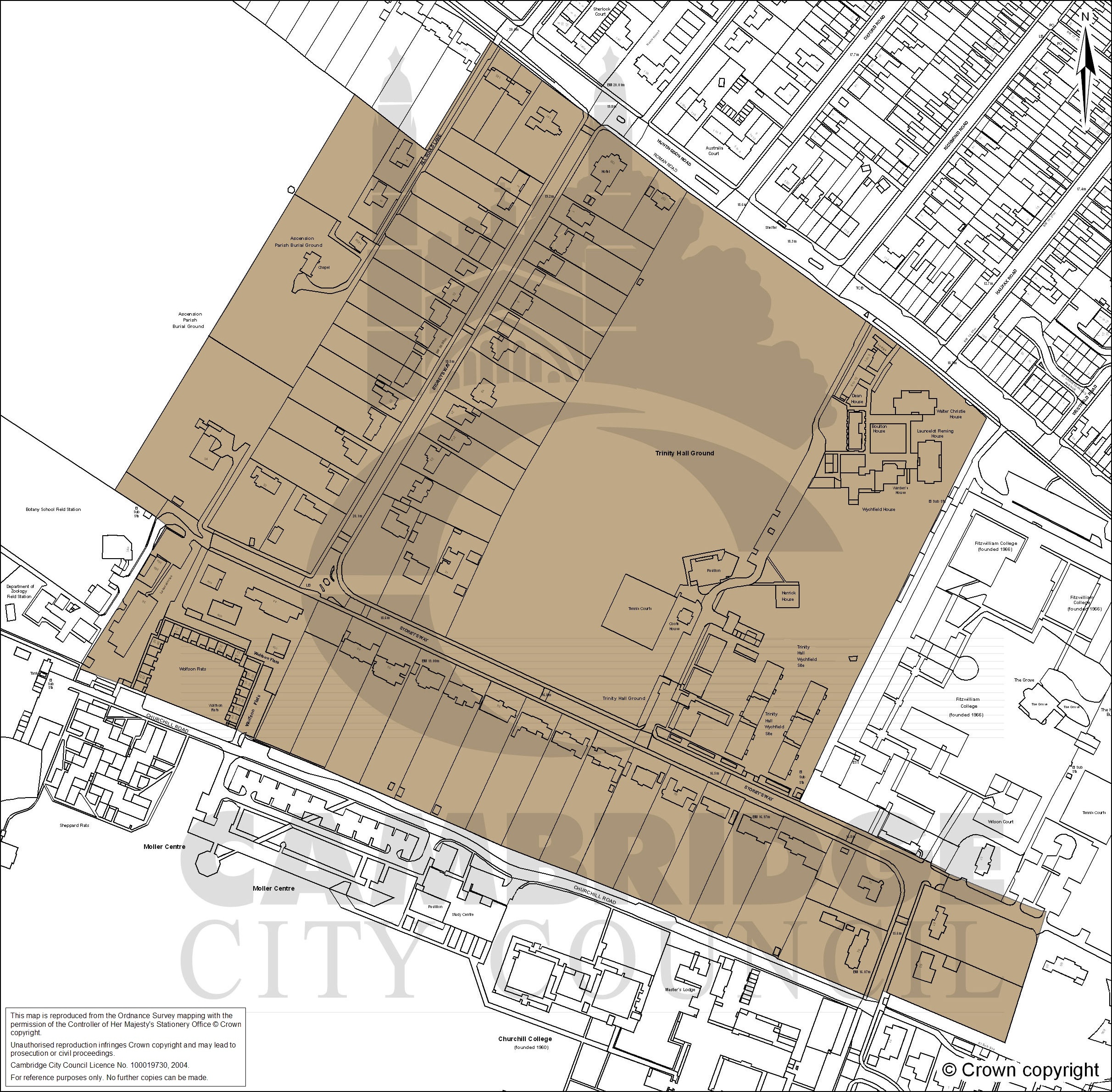
| Name | Storey's Way | Facts |
| Quality | Authoritative: We have some data from the authoritative source | no fact link |
| Dataset | Conservation area | no fact link |
| Organisation | Cambridge City Council | no fact link |
| Start date | 2008-04-08 | Facts |
| End date | Facts | |
| Entry date | 2008-04-08 | Facts |
| Typology | geography | no fact link |
| Geometry |
MULTIPOLYGON (((0.102729 52.217933, 0.102326 52.218132, 0.101976 52.218302, 0.10153 52.218529, 0.100918 52.217949, 0.100312 52.218258, 0.099758 52.217726, 0.098964 52.21697, 0.098201 52.216247, 0.098095 52.216149, 0.098454 52.215996, 0.098541 52.21595, 0.09841 52.21582, 0.098389 52.215797, 0.09808 52.215498, 0.09781 52.215253, 0.09774 52.215186, 0.097876 52.215148, 0.098108 52.215094, 0.098203 52.21507, 0.098324 52.215035, 0.099015 52.214854, 0.099112 52.21483, 0.099255 52.214772, 0.099871 52.214603, 0.100482 52.214431, 0.101416 52.21416, 0.102072 52.213993, 0.102727 52.213817, 0.102969 52.213743, 0.103387 52.213624, 0.103392 52.21363, 0.103805 52.213515, 0.103828 52.213501, 0.104712 52.213256, 0.104721 52.213267, 0.104748 52.213311, 0.105094 52.213215, 0.105817 52.213011, 0.105922 52.213196, 0.106218 52.213728, 0.106142 52.213737, 0.106059 52.213755, 0.105387 52.213936, 0.105353 52.213954, 0.105326 52.213964, 0.105245 52.21399, 0.105141 52.214026, 0.104909 52.214093, 0.104123 52.21433, 0.104062 52.21435, 0.104208 52.214528, 0.104517 52.21491, 0.10471 52.215135, 0.104874 52.215322, 0.104929 52.215387, 0.105051 52.215525, 0.105461 52.216, 0.10562 52.216178, 0.105814 52.216403, 0.105697 52.21647, 0.105332 52.216674, 0.104958 52.216862, 0.104432 52.21711, 0.103716 52.217452, 0.103249 52.217668, 0.102729 52.217933)))
|
Facts |
| Point |
POINT (0.10205 52.215843)
|
Facts |
| Document url | https://www.greatercambridgeplanning.org/media/1632/storeys-way-conservation-area-map.jpg | Facts |
| Documentation url | https://www.greatercambridgeplanning.org/design-heritage-and-environment/historic-environment/conservation-areas/conservation-area-appraisals/#A16 | Facts |
Available Code Snippets:
{
        "entry-date": "2008-04-08",
        "start-date": "2008-04-08",
        "end-date": "",
        "entity": 44002385,
        "name": "Storey's Way",
        "dataset": "conservation-area",
        "typology": "geography",
        "reference": "88",
        "prefix": "conservation-area",
        "organisation-entity": "70",
        "geometry": "MULTIPOLYGON (((0.102729 52.217933, 0.102326 52.218132, 0.101976 52.218302, 0.10153 52.218529, 0.100918 52.217949, 0.100312 52.218258, 0.099758 52.217726, 0.098964 52.21697, 0.098201 52.216247, 0.098095 52.216149, 0.098454 52.215996, 0.098541 52.21595, 0.09841 52.21582, 0.098389 52.215797, 0.09808 52.215498, 0.09781 52.215253, 0.09774 52.215186, 0.097876 52.215148, 0.098108 52.215094, 0.098203 52.21507, 0.098324 52.215035, 0.099015 52.214854, 0.099112 52.21483, 0.099255 52.214772, 0.099871 52.214603, 0.100482 52.214431, 0.101416 52.21416, 0.102072 52.213993, 0.102727 52.213817, 0.102969 52.213743, 0.103387 52.213624, 0.103392 52.21363, 0.103805 52.213515, 0.103828 52.213501, 0.104712 52.213256, 0.104721 52.213267, 0.104748 52.213311, 0.105094 52.213215, 0.105817 52.213011, 0.105922 52.213196, 0.106218 52.213728, 0.106142 52.213737, 0.106059 52.213755, 0.105387 52.213936, 0.105353 52.213954, 0.105326 52.213964, 0.105245 52.21399, 0.105141 52.214026, 0.104909 52.214093, 0.104123 52.21433, 0.104062 52.21435, 0.104208 52.214528, 0.104517 52.21491, 0.10471 52.215135, 0.104874 52.215322, 0.104929 52.215387, 0.105051 52.215525, 0.105461 52.216, 0.10562 52.216178, 0.105814 52.216403, 0.105697 52.21647, 0.105332 52.216674, 0.104958 52.216862, 0.104432 52.21711, 0.103716 52.217452, 0.103249 52.217668, 0.102729 52.217933)))",
        "point": "POINT (0.10205 52.215843)",
        "quality": "authoritative",
        "document-url": "https://www.greatercambridgeplanning.org/media/1632/storeys-way-conservation-area-map.jpg",
        "documentation-url": "https://www.greatercambridgeplanning.org/design-heritage-and-environment/historic-environment/conservation-areas/conservation-area-appraisals/#A16",
        "organisation-curie": "local-authority:CAB"
}Loading...© Historic England 2026. Contains Ordnance Survey data © Crown copyright and database right 2026. The Historic England GIS Data contained in this material was obtained on [date]. The most publicly available up to date Historic England GIS Data can be obtained from HistoricEngland.org.uk.
Licensed under the Open Government Licence v.3.0.
Geographical area
Help improve this data
Give feedback on this dataset, or email your questions and corrections to digitalland@communities.gov.uk.