Conservation area
Ferry Lane
| Field | Value | Fact links |
|---|---|---|
| CURIE | conservation-area:34 | no fact link |
| Prefix | conservation-area | Facts |
| Reference | 34 | Facts |
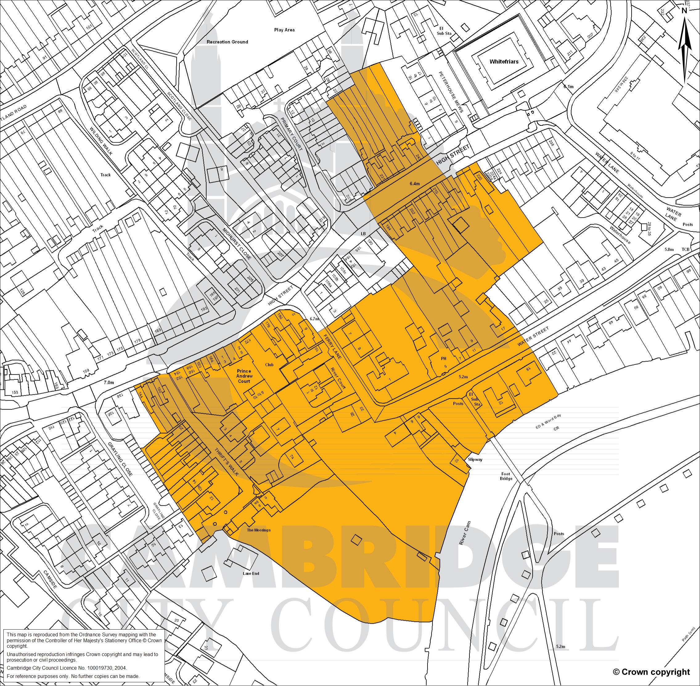
| Name | Ferry Lane | Facts |
| Dataset | Conservation area | no fact link |
| Organisation | Cambridge City Council | no fact link |
| Start date | 2009-06-23 | no fact link |
| End date | no fact link | |
| Entry date | 2009-06-23 | Facts |
| Typology | geography | no fact link |
| Geometry |
MULTIPOLYGON (((0.145008 52.219414, 0.144764 52.21936, 0.144805 52.219309, 0.144565 52.219225, 0.14478 52.219023, 0.144889 52.218858, 0.144943 52.218794, 0.144837 52.218754, 0.144956 52.218617, 0.145235 52.218406, 0.145054 52.218315, 0.145047 52.218321, 0.1449 52.218268, 0.144886 52.218277, 0.144872 52.218274, 0.144444 52.218089, 0.144366 52.218156, 0.144341 52.218154, 0.144306 52.218186, 0.144232 52.218208, 0.144143 52.218207, 0.143803 52.218067, 0.14324 52.217911, 0.143172 52.217907, 0.142957 52.217853, 0.143022 52.217769, 0.143159 52.217618, 0.143021 52.217547, 0.142994 52.217545, 0.143476 52.217063, 0.143555 52.217104, 0.143577 52.217126, 0.143638 52.217132, 0.143688 52.217095, 0.143858 52.217049, 0.143943 52.217017, 0.144219 52.216879, 0.144575 52.216714, 0.144742 52.216655, 0.144818 52.216646, 0.144883 52.216654, 0.144945 52.216674, 0.145153 52.216651, 0.1453 52.21665, 0.145368 52.216867, 0.145361 52.216886, 0.145372 52.216911, 0.145378 52.216984, 0.145439 52.217097, 0.145624 52.217358, 0.145631 52.217375, 0.145625 52.217383, 0.145644 52.217399, 0.145591 52.217437, 0.145658 52.217479, 0.145709 52.217465, 0.145773 52.217521, 0.145946 52.217602, 0.14608 52.217654, 0.146356 52.217739, 0.146366 52.21775, 0.146174 52.217963, 0.146061 52.218067, 0.145985 52.218131, 0.145792 52.218259, 0.145925 52.21833, 0.145914 52.218338, 0.146282 52.218503, 0.146009 52.218767, 0.145953 52.218748, 0.145805 52.218861, 0.145763 52.21891, 0.145593 52.218857, 0.145609 52.21884, 0.145575 52.218829, 0.14556 52.218847, 0.145521 52.218832, 0.14534 52.218983, 0.145324 52.219009, 0.145325 52.219039, 0.145248 52.21912, 0.145008 52.219414)))
|
Facts |
| Point |
POINT (0.144793 52.2178)
|
Facts |
| Document url | https://www.greatercambridgeplanning.org/media/1625/ferrylane-conservation-area-map.jpg | Facts |
| Designation date | 1969-02-25 | Facts |
| Documentation url | https://www.greatercambridgeplanning.org/design-heritage-and-environment/historic-environment/conservation-areas/conservation-area-appraisals/#A9 | Facts |
Available Code Snippets:
{
        "curie": "conservation-area:34",
        "prefix": "conservation-area",
        "reference": "34",
        "name": "Ferry Lane",
        "dataset": "conservation-area",
        "organisation-entity": "local-authority:CAB",
        "start-date": "2009-06-23",
        "end-date": "",
        "entry-date": "2009-06-23",
        "typology": "geography",
        "geometry": "MULTIPOLYGON (((0.145008 52.219414, 0.144764 52.21936, 0.144805 52.219309, 0.144565 52.219225, 0.14478 52.219023, 0.144889 52.218858, 0.144943 52.218794, 0.144837 52.218754, 0.144956 52.218617, 0.145235 52.218406, 0.145054 52.218315, 0.145047 52.218321, 0.1449 52.218268, 0.144886 52.218277, 0.144872 52.218274, 0.144444 52.218089, 0.144366 52.218156, 0.144341 52.218154, 0.144306 52.218186, 0.144232 52.218208, 0.144143 52.218207, 0.143803 52.218067, 0.14324 52.217911, 0.143172 52.217907, 0.142957 52.217853, 0.143022 52.217769, 0.143159 52.217618, 0.143021 52.217547, 0.142994 52.217545, 0.143476 52.217063, 0.143555 52.217104, 0.143577 52.217126, 0.143638 52.217132, 0.143688 52.217095, 0.143858 52.217049, 0.143943 52.217017, 0.144219 52.216879, 0.144575 52.216714, 0.144742 52.216655, 0.144818 52.216646, 0.144883 52.216654, 0.144945 52.216674, 0.145153 52.216651, 0.1453 52.21665, 0.145368 52.216867, 0.145361 52.216886, 0.145372 52.216911, 0.145378 52.216984, 0.145439 52.217097, 0.145624 52.217358, 0.145631 52.217375, 0.145625 52.217383, 0.145644 52.217399, 0.145591 52.217437, 0.145658 52.217479, 0.145709 52.217465, 0.145773 52.217521, 0.145946 52.217602, 0.14608 52.217654, 0.146356 52.217739, 0.146366 52.21775, 0.146174 52.217963, 0.146061 52.218067, 0.145985 52.218131, 0.145792 52.218259, 0.145925 52.21833, 0.145914 52.218338, 0.146282 52.218503, 0.146009 52.218767, 0.145953 52.218748, 0.145805 52.218861, 0.145763 52.21891, 0.145593 52.218857, 0.145609 52.21884, 0.145575 52.218829, 0.14556 52.218847, 0.145521 52.218832, 0.14534 52.218983, 0.145324 52.219009, 0.145325 52.219039, 0.145248 52.21912, 0.145008 52.219414)))",
        "point": "POINT (0.144793 52.2178)",
        "entity": 44002382,
        "quality": "authoritative",
        "document-url": "https://www.greatercambridgeplanning.org/media/1625/ferrylane-conservation-area-map.jpg",
        "designation-date": "1969-02-25",
        "documentation-url": "https://www.greatercambridgeplanning.org/design-heritage-and-environment/historic-environment/conservation-areas/conservation-area-appraisals/#A9"
}Loading...© Historic England 2026. Contains Ordnance Survey data © Crown copyright and database right 2026. The Historic England GIS Data contained in this material was obtained on [date]. The most publicly available up to date Historic England GIS Data can be obtained from HistoricEngland.org.uk.
Licensed under the Open Government Licence v.3.0.
Geographical area
Help improve this data
Give feedback on this dataset, or email your questions and corrections to digitalland@communities.gov.uk.